Mapping
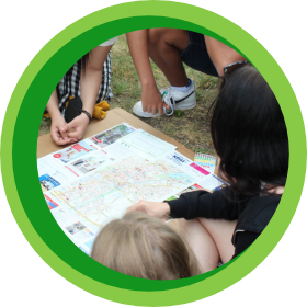
The pupils document different areas and their uses in the school garden and / or the school area. They discuss the different functions that the soil fulfils in these areas and the uses that take place or could take place.
LEARNING GOALS

Pupils can:
- name different soil functions and link them to their own living environment
- apply a mapping method according to the instructions
- represent soil functions on a map
- distinguish and compare common surfacing materials
- analyse different uses and suitable surfacing materials
- develop ideas for the design of the school yard or the school environment
Background Information
Subjects: Geography and Economics, Biology and Environmental Studies, History and Social Studies, Political Education
Required Materials: clipboards, pens, prefabricated maps of the school grounds or the school environment
Required premises/equipment of the rooms: school environment or school open space
Ideal for: small groups and teams of two
Time required: approx. 2 teaching units
Preparation
You can either use the school grounds or the surrounding area as a basis for mapping.
- View the selected area and consider what functions take place (play area, path, seating area, parking, bicycle parking, etc.).
- Prepare a map of the school site or selected area.
- Consider possible hachure or colour divisions for the different functions or uses and create a mapping example to illustrate the assignment.
- If the area is large, subdivide it into smaller areas.
- Familiarise yourself with scale calculations.
Tasks in class
- Explain the task to the pupils with the help of a mapping example. All pupils (or groups) receive a map of the selected site or a certain area.
- The pupils think about possible uses of the areas. Agree with the pupils on certain colours or symbols. Create a legend for the mapping together.
- Afterwards the areas are explored in small groups and documented on the map by hachuring or colouring the different areas on the map or by using symbols.
- The results are placed next to each other and compared. If you divided the area into several areas, a large common map can now be created and hung up as a poster in the class.
- Discuss together which different functions the soil fulfils on the school site or in the school area. The following questions can be raised:
- What are the most common functions?
- Which functions need the most space?
- Which areas fulfil several functions at once?
- Are there other functions available?
- What proportion are green areas vs. grey areas?
- What proportion of the areas is sealed?
- Would it be possible to unseal some areas?
The pupils assess the existing land use, its functions and whether the needs of the pupils are met. They develop suggestions for possible unsealing of the areas with the same or different use to provide more “green” and a better quality of stay. Alternative materials for surfaces can be researched and compared.
HINT

- A focus can also be placed on the plants on the school grounds or in the school environment, for example, the trees can be drawn in, planting beds or hedges can be highlighted.
- As an alternative or supplement to the mapping example, you can record a part of the terrain together with the pupils.
- Give the students the homework of mapping their living environment. In the next lesson, the results will be compared with the results of the mapping of the school grounds. Are there features that occur only on the school grounds but not at home? Which features occur in both grounds? How much space do they take up?